| |
|

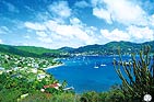
 BEQUIA
(GRENADINES BEQUIA
(GRENADINES
DE ST-VINCENT)
18 sq km in area, Bequia (pronounced
Bek-way) is the largest of the St Vincent
dependencies. Its terrain is volcanic in
origin and a ridge of hills runs from one
end of the island to the other. The
population is about 5000 and is a
complicated mixture of mainly black
African ex-slaves and old European
colonists, mainly Scots and French. To
those must be added fishermen from
New Bedford (USA) who came in the
19th century to hunt whales and taught
the skill to the local fishermen. Whale
hunting still takes place at the cost of
those rare cetaceans that still pass close
to the coast, though the catch is
stringently policed by international
regulations. Each extremely rare ‘event’
is announced by a look-out and puts the
whole small fishing community into a
hubbub. Once aboard their frail skiffs
they try to harpoon the whale and bring
it back to Petit Nevis Islet in order the
better to be able to cut it up and sell it
in a general atmosphere of celebration.
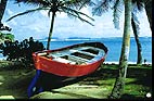
This traditional practice has naturally
also resulted in the fishermen being good
boat builders. Although made only from
local materials and with their own
inherited knowledge and skills, these
local craft (or country boats) in no way
lack in seaworthiness and toughness.
They are now seen less often through
lack of raw materials and skilled
craftsmen.

Coastline and anchorages
W coast
Roughly 6M S of St Vincent, Bequia is
the first of the Grenadines you’ll come
to if coming from the N. The channel
between St Vincent and Bequia is
narrow. Currents are often strong and
when the trade wind pipes up it can be
very rough. Approaching Bequia you
may have to deal with some strong gusts.
Admiralty Bay
From the N enter Admiralty Bay after
doubling Northwest Point. Give the
shoals of Devil’s Table, marked by a W
Cardinal buoy, a good berth.
Caution Night entry is not advisable
because the lights are unreliable.
|
|
|
|
Lower Bay and Princess Bay
These anchorages, with their fine
beaches, are in the south part of
Admiralty Bay. They are less crowded
but often very rolly or disturbed by a
sharp chop.
Caution Going towards Port Elizabeth and
Lower Bay, steer clear of the shoals off
Princess Point.
Ashore There are some small restaurants
along the shore or up the hill, with a
wonderful view.
Port Elizabeth
Two anchorage areas are separated by an
unbuoyed channel leading to the ferry
dock, which must be kept clear:
• to the SE close to the village
• to the north between the fuel dock and
the small Daffodil water/diesel boat jetty
(they will deliver).
In the latter there’s a wreck with 4m over
it, which has already snagged more than
one anchor. Although the bay is huge
there’s not often a lot of room in the SE
corner because of the number of boats and
moorings. Depths vary from 5m to 12m
with only moderate to poor holding.
Mooring buoys, for which there’s a fee,
are often available.
Caution There’s a speed limit of 5 knots
in the anchorage, although local boats
don’t pay much attention to it.
Lower Bay and Princess Bay
These anchorages, with their fine
beaches, are in the south part of
Admiralty Bay. They are less crowded
but often very rolly or disturbed by a
sharp chop.
Caution Going towards Port Elizabeth and
Lower Bay, steer clear of the shoals off
Princess Point.
Ashore There are some small restaurants
along the shore or up the hill, with a
wonderful view.
South Coast, some other moorings :
Friendship
Bay
Petit Nevis
Isle Quatre
Isles Baliceaux
and Battowia
|
|
|